Evacuation Seen Difficult near Restarted N-Plant in Miyagi
Newsfrom Japan
Society- English
- 日本語
- 简体字
- 繁體字
- Français
- Español
- العربية
- Русский
Ishinomaki, Miyagi Pref., Oct. 30 (Jiji Press)--Intricate landforms in areas around a just restarted nuclear power plant in Miyagi Prefecture are seen making evacuations difficult in the event of a serious accident at the plant.
The No. 2 reactor of Tohoku Electric Power Co.'s Onagawa plant, which went back online Tuesday, is located on the Oshika Peninsula featuring a number of ria inlets, winding mountain roads and scattered islands with limited means of transportation.
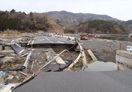
When a 9.0-magnitude earthquake and monster tsunami struck coastal areas of the northeastern Japan region of Tohoku, including the prefecture, in March 2011, two prefectural roads on the peninsula's coastline were partially damaged and closed while an inland road was hit by landslides at nine locations and residents in nearby communities were left isolated for some 10 days, according to the Miyagi prefectural government's road division.
Since then, the Miyagi government has transferred roads to higher locations and implemented measures against possible mudslides on slopes. However, a new tsunami hazard map shows that 14 sections of two prefectural roads could be flooded if an earthquake as powerful as the 2011 quake occurs.
In the Yoriisohama district of the Miyagi city of Ishinomaki, located some 2 kilometers southeast of the nuclear plant, co-hosted by Ishinomaki and the adjacent town of Onagawa, a narrow municipal road is the sole evacuation route. Although evacuations by such means as helicopter and ship would be possible, residents in principle are expected to use a route close to the Onagawa plant to reach the inland area.
[Copyright The Jiji Press, Ltd.]

